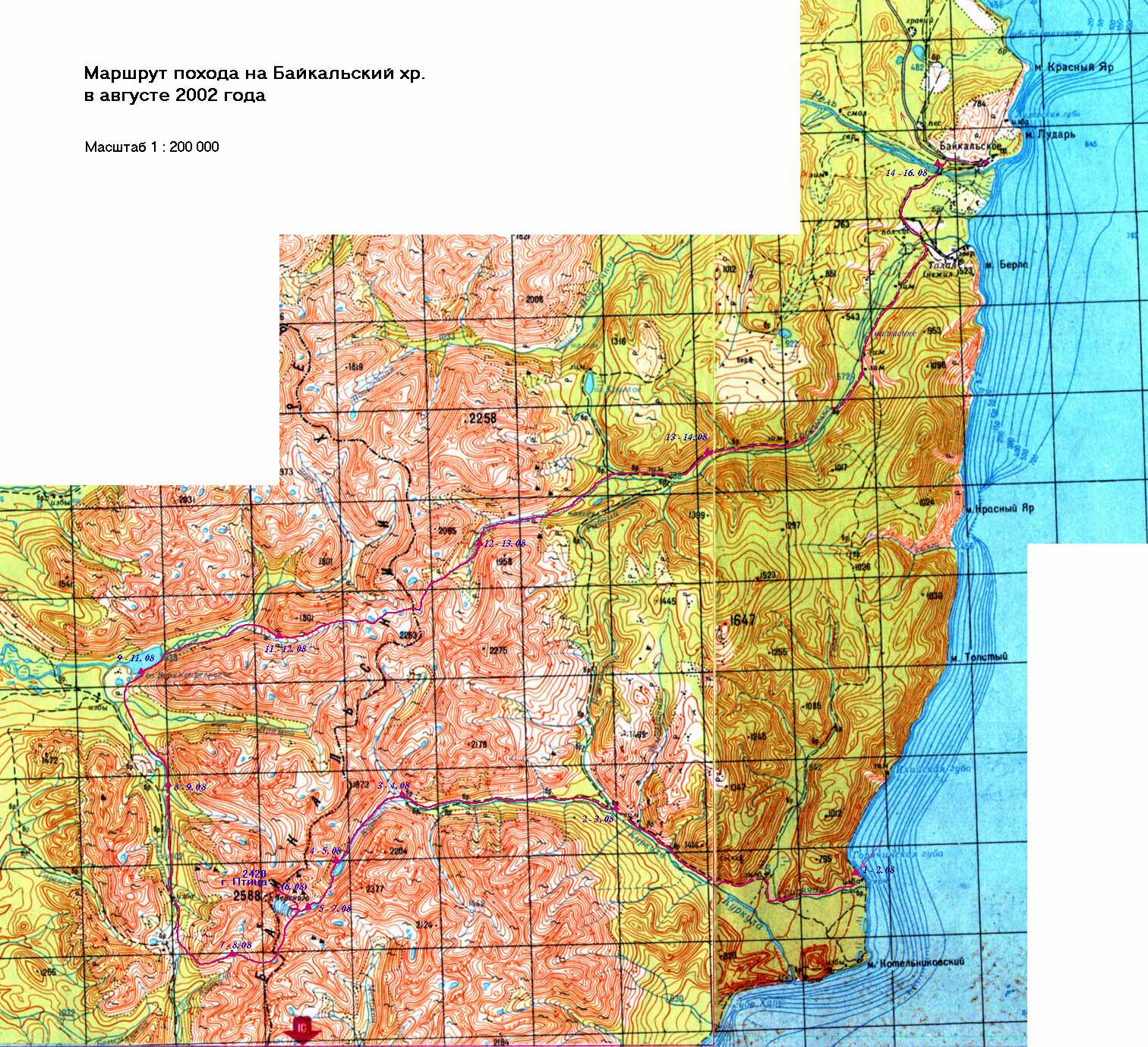
Baikalsky mountain ridge is located near the North-Western coast of the
Baikal lake, in Siberia. It is not very high (the highest mountain is 2588 m),
but as we all think, is is full of contrasts and very beatiful.
There is a lot of small lakes with
water of different colors up in the valleys. There are water-falls on the
streams near passes. There are several small
glaciers and a lot of small snow-fields up in the valleys and close to the
highest mountains and passes even in summer. Down in the valleys it is
warm in summer (up to 25 C). Mountains are rocky.
Eastern side of the ridge
is becoming popular to tourists, and there are pathes in the most popular routes.
However, western side is still visited rarely, so there are no human pathes.
Bottoms of valleys are covered with forest (taiga). Elfin wood grows
their sides and up in the valleys. It is VERY hard to beat one's way
through the elfin wood jungle. Sometimes, you can walk several hundred
meters by interweaved branches of this cedar-wood bush without stepping down
to the ground. Fortunately, we had such terrible track only for one day.
On other days we went through the wild forest or by stone-fields.
We went by human pathes for first 4 and last 1.5 days.
Baikalsky mountain ridge is rather easily accessible: BAM railroad is not very far away.
It takes 4 days to get there by train from Moscow, plus a 5-hour trip by boat.
It is not convenient to get there by airplane. However, you can get there by speed-boat
from Irkutsk (on the south-west coast of Baikal), which has an airport.
Local villagers said that they met two Czech and three Poland tourists
about two days before we finished our trip. We also read notes written by
Polish tourists at the top of the Ptitsa (Bird) mountain.
You are welcome! But it is better for you to be able to speak Russian,
at least a little.
Contents:
Technical report about the trip. In Russian only. If you're going to visit Baikalsky mountains, probably I can translate this long text upon request.
Mountaineering (backpacking) in Caucasus mountains (July 26 - August 13, 2003) Маршрут: С. Верхний Баксан - р. Курмычи - пер. Джаловчат (1Б, 3270) - пер. Адылсу (1Б, 3300) - поляна "Зеленая гостиница"
- пер. Гумачи (2А, 3540) - а/л Уллу-Тау - с. Верхний Баксан - оз. Сылтранкель - пер. Мукал (1Б, 3687) - пер. Ритенок (2А, 3500)
- пер. Российских Офицеров (2А, 3500, рад.) - пер. Джикаугенкез (Чаткара) (1А, 3520) - пер. Ирикчат (1Б*, 3643) - пос. Эльбрус
- пос. Терскол - г. Чегет - оз. Донгуз-Орун
- Brief technical notes (in Russian) (черновой вариант)
- Очень простая "троечка", к тому же все сложные участки (ледопад на пер. Гумачи и разорванный ледник на пер. Ирикчат) были закрыты снегом. Очень много снега было на Кавказе летом 2003 года.
- Взял предельно мало личных вещей, поэтому идти было легко. Даже в "лоси" попал, удивительно :)
- После похода с частью группы поехал на море в Абхазию (15 - 22 августа)
Mountaineering (backpacking) in Caucasus mountains (August 2001) Маршрут: С. Булунгу - пер. Кору (1А, 3650) - пер. Тютюргу Вост. (1Б, 3750) - т/б Чегем - т/б Башиль - пер. Штернберга (2А, 3900) - пер. Студенческий (1Б, 3630) - пер. Водопадный (1Б, 3480) - а/л Уллу-тау - пер. Голубева (2А, 3765) - пер. Грановского (2А, 3950) - пос. Верх. Баксан - Азау - Приют 11-ти
- Ну и угораздило же меня пойти сразу в "тройку" с Горным турклубом МГУ :) . Тяжело мне там пришлось. Зато увидел, что такое "спортивный" поход и перевалы 2А к.с.
Backpacking in Khibiny mountains (on Kola peninsula, rather close to Norway and Arctic Ocean) (15 - 24 August 2000) Маршрут: Кировский рудник - пер. Ворткеуайв - оз. Академическое - пер. Юж. Рисчорр - пер. Вост. Петрелиуса - пер. Ферсмана (1Б) - пер. Юмъекорр - расщелина Аку-Аку - ст. Имандра
- руководитель - Леша Сальников
Youth expedition to Polar Ural (June 1999) - it is my favorite region!
Have you ever been to tundra? It's beatiful!
"Комплексная экспедиция отдела Астрономии и космонавтики Московского городского Дворца творчества детей и юношества" (МГДТДиЮ) Маршрут: оз. Большое Щучье - р. Щучья - факт. Лаборовая - р. Щучья - мост трассы Ямал-Салехард.
- Гуляние по окрестностям (тундра!), лов рыбы и сплав на надувных резиновых лодках.
- Три с половиной недели автономки.
Youth expedition to Polar Ural (July-August 1998) "Комплексная экспедиция отдела Астрономии и космонавтики Московского городского Дворца творчества детей и юношества" (МГДТДиЮ) Маршрут: оз. Хадатаеганлор - р. Хадата - р. Щучья - мост трассы Ямал-Салехард.
- Гуляние по окрестностям (тундра!) и сплав на надувных резиновых лодках.
- Три с половиной недели автономки.
- Мой первый серьезный поход. До этого даже в ПВД в Подмосковье не ходил :)
- Четыре недели полнейшего кайфа ;))) Еды мало, мошка жрет, но тундра - как же это красиво! И люди подобрались хорошие.
Resting on "Moscow Sea" (June 1996) не поход, а так, отдых на острове с катанием на катах-2 по водохранилищу в составе кружка оборонно-массового отдела МГДТДиЮ